Exercise Rural
| Information on the exercise Rural Water Management week 38 and 39. |
| Link to computation exercise |
| Link to text exercise, update 11-9-2013
Link Drawing version 1 as A3 pdf |
| This exercise is a simplified version of the course assignment Rural water management. In general this exercise contains all the aspects of the course assignment. Each group gets a different map. During class, in week 40 each group will give a presentation of 5 minutes. |
| Water management in a polder has to deal with: • Discharge of surplus rainwater. • Discharge of seepage. • A optimal groundwater level and surface water level related to land use. • Enough storage to prevent flooding with extreme rainfall |
| The goals of this exercise are: (or the questions which should be answered) • Calculate the discharge capacity of the pumping station in m3/hour • Find the optimal water level (fixed water level) of the surface water (ditch) • Design of the weir between the two level agreement area’s • Design of the two cross sections of the ditch. • Design enough storage to prevent flooding with extreme rainfall. |
| Preconditions: • Levels and areas according to the drawings. • The main ditch is divided is two parts, part 1 is upstream of the weir, part 2 is downstream of the weir. Side slope ditch is 1:2 at both sides. Minimal water depth ditch is 0,5 m. • Pump capacity is 15 mm/day. It is not allowed to change the pump capacity. • The length of ditch part 1 is 2500 m, part 2 has a length of 3000 m. • Preferred freeboard of 1,2 m. • Maximum velocity in ditch is 0,3 m/s. • Manning’s roughness coefficient for the ditch is assumed to be 0,045 [s/m1/3] • With at constant rainfall of 15 mm/day , rise of the water level may not exceed 50 cm. • The polder should be able to cope with an extreme rainfall of 91 mm in 4 days • Storage coefficient of 0,15 or 15% in the soil above groundwater level. This means that 1 m3 soil can contain 0,15 m3 water, • On a yearly basis 300 mm of rainfall will be discharged by the pumping station. |
| Assumptions / simplifications: • Drawing is not on scale. • Cross-section ditch part 1 does not change and cross-section ditch part 2 does not change. Bed level ditch of both parts is horizontal. • The ground level in a discharge area is the same everywhere. • The seepage is about 2 mm each day. The area where seepage occurs is 20 ha. The seepage will flow into the polder. • When the extreme rainfall starts, the groundwater level is on the same level as the water level in the ditch. • Flooding because of extreme rainfall is only checked at the end of the rainfall. • All rainfall infiltrates in the soil. There occurs no surface runoff. This does not mean that al the rain water stays in the soil. This means that the rain water will flow into the surface water through the soil. • Assumption is that a specific freeboard of the surface water lead to an optimal groundwater level. • We take only the primary watercourse (ditch) into account. In reality you also have secondary and tertiary ditches. This is important for storage. |
| Concepts • The water board is responsible for choosing and maintaining the fixed surface water levels. • The catchment area is divided in fixed drainage level area’s (level agreement area) [peilgebieden]. In a fixed drainage level area, when it is not raining, the surface water level is at a fixed level. Often there is a fixed winter level and a fixed summer level. In the exercise there will be one fixed (agreed) surface water level • A fixed drainage level area (level agreement area) is often divided in smaller discharge areas. For reasons of simplification these discharge areas are connected at one location at the ditch. A discharge area has the same soil type. In Sobek these discharge area are the unpaved areas, which are connected to the ditch. In the drawing these are the yellow lines and dots. In this exercise you are not going to use SOBEK • At the border between two fixed drainage level areas there is a difference in water level. To achieve this a weir is used. Only in extraordinary situations a pump is used, this because the costs of a pump. In this exercise there is only one pump at the downstream end , as shown on the drawing. • A weir is only useful if de upstream water level is higher than the downstream water level. • With rainfall the discharge in a part of the ditch is based on the upstream connected area. • Concerning Fluid Dynamics, there are two situations to be checked: 1. Does the ditch has enough discharge capacity when the pump is working? 2. Does the ditch has enough storage capacity with extreme rainfall? |
| Steps 1. Calculate the fixed water levels for both the fixed drainage level areas (level agreement areas) [peilgebieden]. This based on the preferred freeboard (1,2 m) and the ground levels of the discharge areas. Note: You will find that it is not possible to have a freeboard of 1,2 m at every location. You have to make choices. 2. Calculate the pump capacity in m3/hour and m3/s. 3. Calculate the maximum discharge in both parts of the ditch, based on a constant rainfall of 15 mm/day 4. Calculate the minimal wetted area for the ditch in part 1 and part 2, given that the maximum velocity is 0,3 m/s 5. Design the cross-section of the ditch in part 1 and part 2 6. Design the weir, based on a constant rainfall of 15 mm/day 7. Calculate the rise of water level at different locations in ditch when: – the pump is using full capacity – constant rainfall of 15 mm/day, all the water is flowing into the ditch 8. Check if the maximum water rise is below 50 cm. If this is not the case, make necessary adjustments on the ditch and/or weir. 9. Put all numbers in the drawing and also draw the water level with 15 mm/day. 10. Calculate how many hours during one year the pump has to discharge water. 11. Check if flooding occurs with the extreme rainfall of 91 mm in 4 days. Only calculate the situation at the end of the rainfall, so after 4 days. 12. If flooding occurs, design some solutions. |
| Drawing |
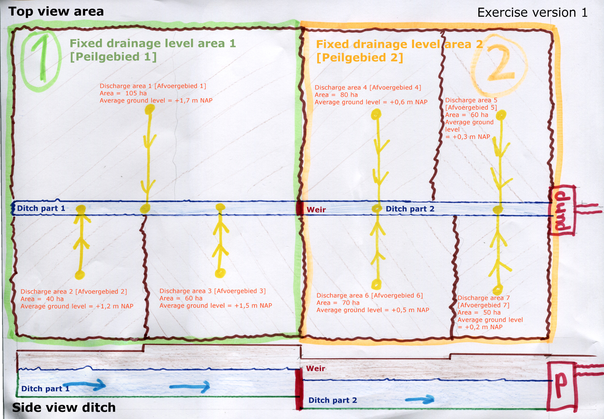 |
| Cross-section |
 |
| Video explanation drawing topview and siteview |
| Video explanation drawing cross-section |
| Video goals |
| Video preconditions |
| Video assumptions |
| Video concept fixed surface water level or agreed surface water level |
| Video concept water levels in ditch |
| Video concept calculation fluid dynamics |

Leave a Reply